Several large-scale industrial projects are being planned in Satakunta. The most significant include data centers, solar and wind energy, hydrogen economy-related investments, and a TNT factory. What all of these projects have in common is the need for various survey and measurement services, both during the planning and construction phases as well as in the documentation of the completed work. Vitomittaus has an office in Pori, so as a local operator, we can offer comprehensive measurement services for all stages of the projects. Feel free to contact us and ask for more infromation!
Surveying Consultancy Firm – Service of Unmatched Quality
Vitomittaus Oy is a surveying consultancy firm offering expertise for even the most demanding measurements across Southwest Finland, and throughout the country as needed. Our services include construction surveys, municipal technical surveys, laser scanning, hydrographic surveys, and aerial photography.
Vitomittaus Oy
Vitomittaus Oy is a surveying consultant operating from Southwest Finland since 2001. Our main services include construction and municipal engineering measurements, terrain mapping, UAV photogrammetry, laser scanning (UAV / ALS / mobile / terrestrial) and bathymetric surveys with multibeam sonar. With the highest grade modern equipment and our skillful staff we can provide you a solution to even the most challenging surveying tasks.
Contact us for more information! We are happy to provide a quote for your project.
News
-
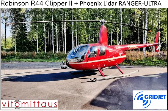 13/01/2025 0 CommentsAirborne laser scanning with helicopterRead More
We have started a collaboration with the Finnish helicopter operator GridJet, and offer now airborne laser scanning with a manned helicopter. This enables larger and more challenging projects, such as scanning vast forest areas and power line surveys. Get in touch and ask for more information!
-
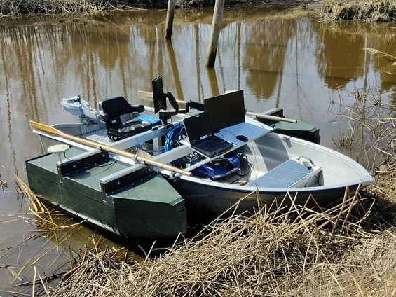 01/10/2024 0 CommentsSurveying of Shallow Water Bodies!Read More
Our new customized survey vessel enables multibeam surveys even in very shallow waters, down to a depth of just half a meter. The sensor used is the Teledyne Marine SeaBat T20-P multibeam echosounder. Thanks to the electric outboard motor, the surveying process is also noise-free, minimizing disturbances for shoreline residents and the environment. The first projects have already been completed for clients, with excellent results!
Diverse Surveying Services
Our wide range of services includes construction surveys, municipal technical surveys, laser scanning, hydrographic surveys, and aerial photography.
Accurate Construction and Land Surveys
We conduct precise surveys for building construction and infrastructure projects. Our services include construction surveys, municipal technical surveys, land surveys, density tests, and 3D machine control. Discover more about our diverse services and contact us today!
Laser Scanning Services
We perform laser scanning for various types of sites. These results can assist in planning, documenting work stages, and creating simulations or visualizations. We deliver the data in the required format and coordinate system, and adjustments can be made flexibly.
Hydrographic Surveys on Inland and Coastal Waters
We conduct hydrographic surveys with reliable precision. With our advanced equipment, we can quickly capture a clear image of underwater shapes and structures, such as wrecks, pipelines, and cables. Our compact equipment allows us to perform surveys in both inland and coastal waters, including narrow channels.
High-Quality Aerial Photography
We conduct aerial photography with high quality across a variety of locations. We provide sharp, high-resolution still and video images as per your needs. We also offer georeferencing, orthomosaic imagery, and surface models. We always adhere to client requirements, environmental and weather conditions, and applicable regulations