The laser scanning (LiDAR) Riegl VUX-1 series of digital waveform analysis technology multi-point scanner.
-Long Distance measurement and high accuracy (achieved by waveform analysis technique).
-Penetrates through the vegetation (only possible with multi-point measurement equipment).
-Works well also in monotonic environments where scanning UAVs image algorithms do not work.
-Allows the measurement at nighttime, regardless of the object illumination.
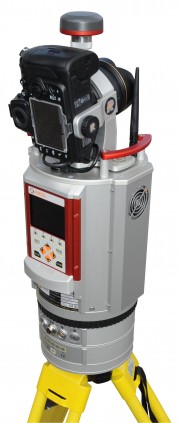
Riegl VZ400 digital laser scanner
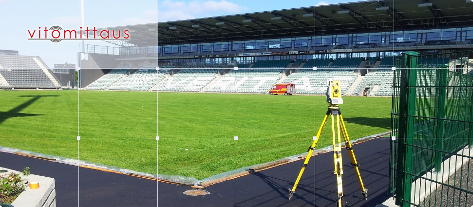
The static laser scanning
3D laser scanner Riegl VZ-400
Multi-point measurement 1.5 ... 600m (0.5 ... 700m)
Two measuring frequencys 300 kHz, and 100 kHz. Measurement accuracy ± 5mm [at] 100 m.
Repeating accuracy ± 3mm [at] 100 m.
Measuring rate 120 cross sections per second. Operating temperature + 40 ° ... -40 ° C.
Nitrogen-flushed terrain measuring device. IP 64 rating.
Signal processing, echo digitization and real-time full-waveform analysis.
Wave form analysis based multi-point measurement analyzes and calculates multiple measuring points from the return signal per measurement pulses sent, if the beam hits sequential objects. The amount of points calculated from a single pulse is unlimited.
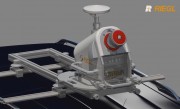
Riegl VMQ-1 mobile laser scanning system
Mobile Laser Scanning
Riegl VMQ-1 mobile laser scanning system
Mobile Laser Scanning provides precise, comprehensive measurement data on the built environment - reached accuracy depends on the hardware used and the skilled user.
Advantages:
Safe.
Operators are in the vehicle, not in the middle of heavy traffic in the road area.
Drives the same speed as the rest of the traffic.
No disturbance to other traffic, no special arrangements.
Cheaper than traditional measurement when measuring range increases
Fast.
Quickly mobilized.
With a good system the result gives much more details than a conventional measurement.
RiCOPTER Automatic RPAS laser-scanning system
UAV aerial laser scanner
UAV hype -Why laser scanning RPAS-UAV?
Advantages of the RPAS airplane.
-Fast deployment
-Flexibility
-RPAS- UAV aerial laser scanning breaks new ground by bringing the benefits of traditional aerial laser scanning easier to use.
Automatic measuring system.
Octocopter
Folding wings.
MTOM <25 kg.
- Max. 16 kg payload (batteries and measuring devices)
- Max. flight time of 30 min per battery set.
Deliveries as standard 3 battery sets = 1hr 30 mins.
Optimized for RIEGLVUX-SYS.
About Riegl technology
NEW TECHNOLOGY
In RIEGLs V-Series devices, digital processing of return signal allows separation of up to 16 - ∞ measuring points from measuring pulse in real-time instead of earlier one point.
In RIEGLs digitized Q Series aerial laser scanners pulse is stored as a whole, allowing separation of unlimited measurement points from a single pulse in post-processing.
WHAT IS MULTI-POINT LASER?
Multi-point laser is based on pulse laser (Time of Flight), ie the pulses round-trip time measurement. Multi-point technique (Online Waveform Analysis) return signal is digitized, making it possible to separate a number of echoes. If the measuring pulse meets planar surfaces sized at least the size of beams entire cross-section, the surface creates one echo. Shape of the echo depends on the material, color and softness of the material. When measuring pulse hits partially different surfaces, the returning echos shape is indefinite or consists of several, different shaped, echoes separable from each other.
REAL-TIME INTERPRETATION OF MEASURING PULSE
Digitizing the entire return signal allows separation of echoes from each other. Each partial echo is compared to the echo library, when the echoes of various shapes can be interpreted mathematically by calculating with different formulas. At the same time the calculated points can be classified by measuring order as well as by quality.
What are the advantages of multi-point laser?
When comparing multi-point laser technology to the normal pulse lasers, the biggest advantages consist of: measuring accuracy, possibility of measuring on covered area and the possibility of classification of measured points to speed up processing (editing) of data.
Measurement accuracy is improved, because measurement points from different materials can now be calculated using each materials return pulses specific form.
In a sense, obstructed areas can also be found when measuring interior spaces and piping. Some of the measuring pulses reaches the edge of the column or tube, some continue to the next surface. The same measurement pulse can "touch" many surfaces until it is completely reflected back. In Point Clouds appears "air points" and point showers at the edges of poles and pipes which makes editing of data difficult. In multi-point technique, the above-mentioned points hardly present, but different points are formed o each "touched" surface. In addition, the classification of measured points enables automatic editing.
When measuring outside, grasses, shrubs, tree branches, etc. prevents a complete penetration of the beam to the actual desired measurement surface. In this case the calculated measurement point is not on desired surface, but lies somewhere in between the first and last contacted surfaces. In multi-point technique on covered surface different contact surfaces are created as own classified outlets, which also creates classified point to the desired surface.